![[object Object]](https://umsousercontent.com/lib_EuhSXxjdIHnRGpWc/t6d8ve7lxv4xzpc5.png?w=318)
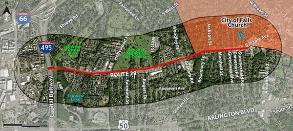
Fairfax County Department of Transportation (FCDOT) has launched a new study of transportation conditions along Route 29, from the Beltway to Tripps Run at the City of Falls Church / Fairfax County border, just east of South Maple Avenue.
As part of this effort, FCDOT is gathering public feedback on how people walk, bike, drive, and take transit along the corridor—and what improvements are most needed. This stretch of Route 29 has long been a challenging connection point between the City and the County. Many residents have raised concerns about unsafe crossings, signal timing, and the lack of pedestrian-friendly infrastructure. This is an important moment to speak up.
Survey Link (fill out before Dec 19, 2025): https://publicinput.com/route29-at-study
Things to consider mentioning:
- Reconnect the two neighborhoods divided by Route 29—improve crossings, calm traffic, and create a more welcoming entry into the City.
- Create a safe bikeway along the entire corridor—connect the City of Falls Church to the Merrifield commercial district with a bikeway that allows for safe travel along the corridor that connects housing, businesses, Capital Bikeshare stations, and bus stops along the way.
- Dangerous crossings between Marshall and Maple/Cavalier—especially at Marshall (drivers running red lights) and Westmoreland/Summerfield (major cut-through, very unsafe to cross).
- Add safety infrastructure at Westmoreland/Summerfield—options include a HAWK signal, raised crosswalk, or pedestrian refuge island using space from the reversible lane.